A Paper presented to the Annual Meeting of the Archeological Society of Virginia, 1996, slightly revised 2022
L. Daniel Mouer, Ph. D.
Archaeology has been taught regularly at VCU since the early 1960s when Dale Kerby first began offering classes at what was then Richmond Professional Institute. Our summer field school has been offered regularly since at least 1969. In the early years, it was always a cooperative venture between the University and the Richmond Chapter of the ASV with collaborations on sites such as Posnick, Deep Bottom, and Rodgers. This evening I would like to take this opportunity to blow VCU’s horn a bit and talk about some of our contributions to the prehistory of the Greater Richmond area.
It is a sad fact that very little prehistoric archaeology of importance has actually been done within the city limits of Richmond. There are a few notable exceptions, but most of what we know about the prehistory of the Falls of the James area comes from field school excavations by VCU and research projects by the ASV in Henrico and Hanover Counties; a few large-scale CRM projects, such as the Henrico, James River and R-MAAS projects conducted by VCU, and studies by James Madison University on VDOT projects such as Rt 288. These CRM projects were all primarily in Henrico, Goochland, Powhatan and Chesterfield Counties.
My first field experience was at the Rodgers site on the north bank of the Chickahominy, in a 1973 field school taught by VCU faculty Brian Hayden who was assisted by John Saunders, then a VCU student and long-time member of the Greater Richmond Chapter. I also worked with VCU faculty member Mark Druss and Saunders at the Shockoe Slip Site in downtown Richmond in 1974. After finishing grad school, I returned to VCU in late 1977, and I have been there ever since. With colleagues like Robin Ryder, Doug McLearen, Chris Egghart, Rob Hunter, Steve Perlman, Gordon Bronitsky, Fred Gleach and others, I have been privileged to see a fairly coherent picture of the region’s prehistory emerge from the rather sketchy, and somewhat flawed, culture history bequeathed us by the pioneering typological studies of Joffre Coe and Clifford Evans. Much of this, I like to think, is due to pioneering archaeological work done at VCU. So now that I’ve made my boastful intentions clear, let me talk about what I feel have been some of VCU’s major contributions.
***
Certainly the first and singly most important task of prehistoric archaeology anywhere is to develop a useful and detailed sequence of phases, cultures, or periods of occupation. Because Richmond sits at the interface between major Southeastern and Northeastern culture regions, and between the coastal or estuarine-focused habitats and cultures of the Middle Atlantic littoral and the vast interior uplands of Eastern North America, our local chronological sequence is complex, to say the least. My colleagues and I realized that fact early on and realized, too, that no straightforward sequence worked out in the Carolina piedmont, nor a pottery typology based on a statewide sorting of temper categories, could possibly adequately describe that complexity. What we needed were fine-grained, highly local, sequences. Deeply stratified sites are not easy to find in Central Virginia and, besides, we usually had to dig where our funding sponsors paid us to dig. This required some innovative approaches. While we could go back and re-study old collections, I felt that we also required some new fieldwork approached with fresh eyes.
The first of my big projects at VCU was the James River Survey. Howard MacCord had published an article noting that very little was known about the prehistory of the Jamers River Piedmont. I undertook some preliminary reviews collections at the VRCA in Williamsburg and noted immediately that sites above the falls of the James, from western Richmond to the Blue Ridge, contained materials and artifact types that were very different from what we find in sites below the falls, from downtown Richmond to the Chesapeake Bay. The James River Survey was a three-year project designed to fill in our gaps of knowledge about the Piedmont James while giving us continuous distributional studies from Cumberland County in the West to Charles City County in the East. The James River Survey provided the principal data for my doctoral dissertation, which focused primarily on the Late Archaic, Transitional and Early Woodland periods. However, we also learned a great deal about the wide variety of Middle and Late Woodland cultures which occupied the Piedmont and the inner Coastal Plain. While much of that information has made its way into the grey literature of meeting papers and contract reports, much more remains to be written and reported about that work.
Concurrent with the James River Survey was the early portion of the Henrico Project, which involved survey of more than 70 miles of sewer line throughout Henrico County. The project lasted nearly 10 years and involved extensive survey, testing and excavation of sites in the Piedmont and Coastal Plain, along the Chickahominy and the James, in uplands and stream valleys, and, most importantly, it included many small streamside camps. Sites such as the Dorey Park, The Four Mile Creek, Bullheller, Moon, and Aignor Complex sites provided chronological information, but getting to it often required special methods. These streamside camps were generally in uniform sandy deposits laid down by overbank flooding or downhill slopewash. Clearly demarcated strata were not to be seen, and the deposits themselves were generally fairly shallow. By excavating in fine levels and using simple regression analysis, we could sort our finely divided pottery types into sequences which overlapped with, or repeated sequences from other sites.
From the very beginning, we gathered soil samples from features such as rock hearths and floated out sufficient charcoal to run C-14 dates, even when charcoal was not obviously present to the naked eye. Our floatations carried the extra boon of providing us with a repertory of charred seeds found in numerous features at different sites, permitting us to get a handle on subsistence practices that otherwise we would not have been able to address.
Another advantage of the small streamside sites is that sometime we were able to isolate single component sites. While Robin Ryder was digging the Dorey Park site on a small terrace of Four Mile Creek, I was immediately across the creek excavating at the Four Mile Creek Site. Robin’s site was deep and complex. It required using statistical magic and very careful field techniques to tease out the depositional and cultural sequence. However, my site was dirt simple: a single campsite occupied just once or twice by a group of folks using Townsend ceramics. This site begged for piece-plotting and spatial analysis using a multivariate statistical technique I developed called factor mapping. We were able to reveal what, to me, was some startlingly clear details of camp structure and activities from what some may have viewed as a pretty slim scatter of potsherds, flakes and fire-cracked rocks stuck off in the woods somewhere.
In 1984 and 1985, with a grant from the state, I conducted what we called the Richmond Metropolitan Area Archaeological Survey–or R-MAAS project. This led to some selective, but intensive surveys at Bermuda Hundred in Chesterfield County, along the headwaters of Swift Creek, also in Chesterfield, and at Curles Neck in Henrico. It involved amassing data on more than 1000 site components from throughout the metro area, placing these data, along with pertinent environmental measures, into a huge computerized data base, and preparing preservation planning tools for three fast-growing municipalities. The R-MAAS surveys were designed to fill gaps in our knowledge, and the data base, while stored on a by-now archaic system, is still probably the best tool for regional prehistory research ever compiled in Virginia.
Doug McLearen and I joined forces to work out some of the basics of a chronological sequence for central Virginia. We tried out types, and associations of types, checked them against the regional literature, checked our dates, regression lines and distribution data, and, finally, the intuitions we were gaining after years of study in this area. We did not accept that any of the established and well-worn typologies in use in this area–namely, those of Coe and Evans–were sacred. On the other hand, we didn’t want to throw them out without good reason. We constructed formal types, checked them against the sequences we were finding, then against the literature: a wide-ranging literature which drew upon the work of Stephenson with the Accokeek creek collection, Ritchie and Funk’s sequences in New York, parallel work by colleagues in Maryland and Delaware, Carl Miller’s deep sequence at Clarksville, and others. We carefully re-read Evans, and I visited Dr. Evans and studied his type collection at the Smithsonian. We also re-analyzed his key data set, which was Ben McCary’s data from the Potts Site. We came to some distinctly different conclusions than had Evans, however, and when we were through, most of Evan’s types were vanquished from Central Virginia–not all, but most. We kept, for instance, his Prince George series, though we discovered he had placed it in the wrong part of the sequence.
Doug and I found we could agree widely on much, disagree about a few things, and claim mutual ignorance on others. All in all, though, we feel comfortable that we have developed a reasonable outline of culture history for the area, and that it is a complex and fascinating one. We feel we have contributed considerable insights about settlement patterns, subsistence practices, and regional exchange and interaction patterns, at least for the period from the Late Archaic through Contact.
***
During the early days of the Henrico Project I set out to look at prehistoric ceramics in some ways that had not been tried here before. While the typological techniques we used were straightforward and traditional, though perhaps more fine-grained than earlier attempts, I felt that pottery had much more to tell us. In that belief I was joined by my VCU colleague Gordon Bronitsky. Bronitsky attacked trends in pottery-making technology through the use of materials-science approaches, while I set out to use clay sourcing to shed light on other aspects of prehistoric social systems. Together we discovered a few interesting things. Early Woodland potters, for instance, were fine craftspeople but they had only limited knowledge of ceramics technology and the characteristics of available materials. By the Middle Woodland I period, however, local potters had a very sophisticated understanding of their technology.
They chose clays, clay preparation techniques, and firing methods any competent potter today would duplicate–if they didn’t have commercial clays, motor-powered wheels and electric kilns. So, when we find differences in temper, vessel thickness, lip finish, etc., we know now that these were carefully chosen attributes designed for specific functional or formal purposes. We know that it matters a great deal whether surfaces were textured or not, and if so, with twined fabric, wadded netting, or cord-wrapped paddles.
We know, too, that in the Middle Woodland period pottery was made using local clays at small streamside camps. In fact, in the inner coastal plain, we feel that this and other lines of evidence lead to the conclusion that most Middle Woodland folks lived most of the time on small streamside camps, and that they lived at these camps in small band-size groups for rather lengthy periods. Their pottery types also evolved in intensively localized styles. This observation flies in the face of most settlement models for this period, especially considering our conviction that some groups of the Early Woodland period had lived in large, perhaps permanently occupied, villages . And yet these Middle Woodland folks were no isolated forest bands, for we know of at least some long-distance trade and interaction among some Middle Woodland peoples, and can trace out a sphere of special objects made on special materials–certain bifaces–which were apparently widely traded, and a unique pottery decorative style–zoned incised and/or zoned punctate–which had some as yet not fully understood significance across the Mid-Atlantic region.
In similar manner we can trace extensive networks of interaction in the late Middle Woodland or early late Woodland cultures of the Piedmont, in a complex that includes maize agriculture, Levanna points, Jacks Reef points, gorgets, tobacco pipes, etc. This may be the first true Late Woodland culture in the region, and it was well represented at the Shockoe Slip site in downtown Richmond before bulldozers blew it away to make room for a new expressway.
Our pottery studies demonstrated that Late Woodland Townsend Complex peoples were very selective in their choices of clays, and that, unlike their predecessors, they did not make pots on their small streamside camps. During this period the camps were almost certainly specialized hunting, fishing or gathering stations used for a brief time by people who otherwise lived in villages. The pots these folks broke along the camps of Four Mile Creek and Upham Brook were made on clays dug at larger sites at Deep Bottom on the James and at the Posnick Site on the Chickahominy River, respectively.
Another VCU innovation, to some extent, was that we often took on excavation on a scale far larger than anything that had been done previously. This was true, for instance, of the Alvis site, where we combined the efforts of professional contract crews and a field school. From the early 1970s our excavations have always included extensive controlled surface collections and/or systematic, close-interval plowzone sampling. Even on small streamside campsites we have preferred to use broad blocks of open-area excavation rather than shotgun scatterings of little holes. We long ago came to believe that there is little to be learned by digging small holes in big sites.
Sometimes innovation doesn’t require new techniques or theories, but simply the careful application of common sense and tried-and-true methods. Careful field excavation techniques have yielded valuable information about prehistoric architecture where previously there was almost none. It is only common sensical to assume that any population of people who came to live in this area after crossing the Bering Sea Land Bridge, surviving the Ice Ages, and learning to adapt to the wide variety of environments the New World had to offer included in their culture kit an equally wide variety of architectural tools. In my first field school at the Rodgers Site in 1974 we excavated dozens, perhaps hundreds, of postholes from different prehistoric periods; many of them were set in the ground at angles indicating almost tipi-like structures. yet once I came to know the extant archaeological literature of eastern and central Virginia, I was shocked that almost no houses had been reported for any period.
Our excavations quickly revealed, as I suspected they would, that many archaeological sites of all periods–especially those which have not been plowed–contain postholes, pits, and other features related to architecture. Over the years, VCU archaeologists have uncovered a wealth of information on lean-tos, cabanas, windbreaks and houses–even some possible fence lines–on prehistoric Native American sites, including many of the small streamside camps we have dug. While doing surface studies of flood-deflated Early Woodland sites in Goochland County I long ago came to the conclusion that the people we know as the Accokeek or Elk Island Complex lived in long-term or permanent settlements with substantial houses. Doug McLearen and Chris Egghart eventually got the opportunity to excavate a portion of one such settlement up in Warren County–far from Richmond, to be sure, but we have no reason to doubt that people here who made the same pottery, axes, points and gorgets did not also live in identical houses. Some day it may be possible to infer seasonality, group composition, and camp function from the study of architectural features on sites of all ages. Continued careful documentation, dating, and reconstruction of such structures is needed before we can come close to understanding the full range of structures and landscapes created in prehistory, but at least we have started down the road.
In more recent years much of our work has brought us back into contact with the Protohistoric and historic Powhatan Indians. Back in the late 1970s and early 1980s I had focused on the historical literature of the local Powhatans, and had begun to get some insights into what I thought their material culture complex might look like. This hinged largely on recognizing the local importance of Gaston and Roanoke ceramics, an insight that developed more or less simultaneously at VCU, and in Charlie Hodge’s work with the prehistoric archaeology at Flowerdew Hundred, and in some insights by Randy Turner, Keith Egloff, Mary Ellen Hodges and others from surveys at Weyanoke Point and elsewhere. I put together a working hyothesis paper called The Occaneechee Connection and brought several of the region’s prehistorians to VCU for a workshop on simple stamped and Potomac Creek-like ceramics. The result was a pretty widespread acceptance that we now, finally, could recognize Powhatan sites in the Coastal Plain and at least some Monacan sites in the Piedmont.
This led to a serious rethinking of the Protohistoric Period and, subsequently, to major excavations on Powhatan sites: especially, the huge sites at Jordan’s Point, dug by VCU, and the Paspehegh Village excavated by James River Archaeological Institute under Mary Ellen Hodges direction. Our new understanding of Powhatan material culture and settlement also made it possible for Randy Turner, Keith Egloff and their associates to recognize beyond a doubt the site of the Powhatan village sitting prominently at the eastern edge of Richmond, at a location where my colleagues and I had gone looking for it, unsuccessfully, in the late 1970s. The site has been subject to a surface study, materials from which were studied at VCU by Doug McLearen. The assemblage includes Powhatan artifacts alongside materials left by Captain John Smith’s detachment left there at what Smith called Fort Nonesuch, after he purchased the palisaded village from Tanx Powhatan. It is also now possible for us to realize that the compact Powhatan village was not typical. Called “Powhatan’s Tower” by contemporary Englishmen, it was clearly a frontier defensive outpost–which is the use John Smith also put it to. More typical were settlements like those at Jordan’s Journey or Paspehegh–what the English called Indian “towns.” They were vast, sprawling landscapes encompassing perhaps hundreds of acres with houses stretching along the rivers in front of extensive fields, woodlands, and special places set aside for sacred and mortuary use.
***
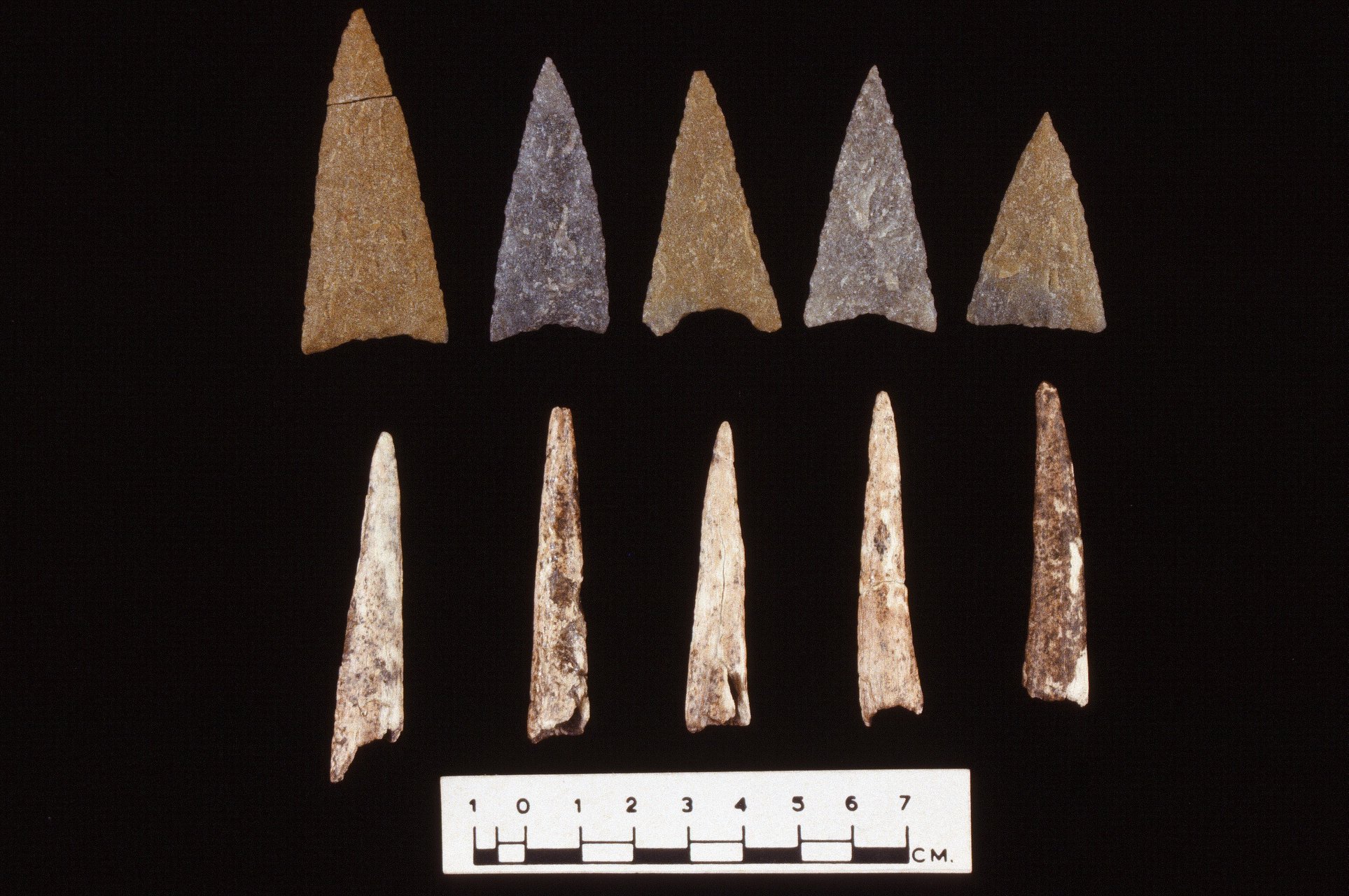
But let’s go back to the city: to those “urban arrowheads” that gave their name to my paper. It’s easy to believe that prehistoric sites have all been destroyed in Richmond’s urban environment except, perhaps, for those on the floodplain of the James River. But the Shockoe Slip site is a sobering reminder of how wrong a notion that is. The site contained a thick, rich midden and covered a huge area, most of which had been removed by bulldozers the day before archaeologists got there. there were at least four human burials. One of these was an adult male buried with a quiver of five arrows tipped with very fine, never used Levanna points. At his waist lay a cluster of nicely polished antler tines, and on his chest was a hammerstone and a stemmed knife that looked for all the world like a Savannah River point. Floatation of the burial fill led to discovery of charred pumpkin seeds and other food stuffs which may have been interred with the body, or simply have drifted in with the midden-rich fill.
The pottery, in 1974, was called “Albemarle,” but I call it Shockoe Fabric-Impressed. By charting the distribution of a complex of materials and associations similar to what we found at Shockoe Slip, I believe we can trace the origins of maize-beans-squash horticulture down the James to the Falls at the beginning of the ninth century. I could be wrong, of course, but the point is, I wouldn’t even be thinking about it had we not found, and made some desperate salvage excavations of, a major prehistoric site sitting on top of a hill that has been densely urbanized since about 1760. And as far as urban arrowheads go: these are mighty sweet to me.
